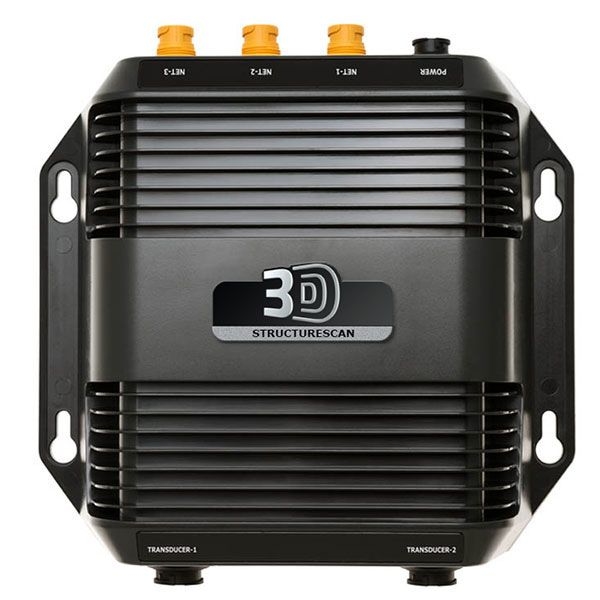
Lowrance StructureScan® 3D allows anglers to see fish, structure and bottom contour in a stunning three-dimensional view. StructureScan® 3D imaging scans underwater terrain and fish-holding structure to create a high-resolution, 180-degree, three-dimensional view beneath your boat. With this unique imaging view, anglers gain a better understanding of where fish and structure are located in relation to their boat. The picture-like, three-dimensional views are displayed on the Lowrance HDS Gen3 series of fishfinder/chartplotters, when used in combination with the StructureScan 3D Skimmer® transducer and module.
StructureScan® 3D
StructureScan 3D is powered by a multi-beam sonar technology that produces revealing images with stunning detail by converting scans of underwater terrain and fish-holding structure into high-resolution, 180-degree, three-dimensional views. The true-to-life 3D scans are displayed on the Lowrance HDS Gen 3 series of fishfinder/chartplotters when used in combination with the SidesScan 3D Skimmer® transducer and StructureScan® 3D module.
Easy-to-Understand Sonar Images
View 3D images from any angle with ScanTrack™ pan-tilt-rotate control using on-screen touch commands and easy-to-use, preset viewing positions.
Find Key Fishing Areas Faster
StructureScan® 3D allows anglers to more easily understand where fish and fish-holding structure are located in relation to their boat. By slowly idling over a potential fishing area with the wide, 180-degree scanning range, anglers can quickly search for key areas and cover ─ such as abrupt depth changes, points, ditches, rockpiles, brushpiles, weedbeds standing timber, wrecks and more.
Key Features
- Unrivaled SideScan Image Clarity
- High Definition (HD) and Super-Wide 3D Scanning
- Leading Edge™ Scanning Reference
- SelectScan™ Target Identification
- Vertical Enhancement Control
- Waypoint Overlay
- Automatic 3D Image Settings
- Ethernet Connectivity
Specifications:
Transmit Power Max RMS: 500W
Cable Length: 20 ft/ 6m
Trandsucer Frequencies: Enhanced 455 kHz
EchoSounder Frequencies: Enhanced 455 kHz
EchoSounder Output Power: Max RMS: 500W
Product Weight: 1.8 lbs \ 0.816 kg
Product Length: 8.26” \ 210 mm
Power Consumption Max: .75A, Typical: .60A, Inrush: 4.7A pk
Power Supply (Supply Voltage): 12 vDC
Input Voltage: 10V - 17 VDC
Cable: 20 ft/ 6m