SPECIFY IN THE ORDER NOTES THE AREA OF INTEREST
Navionics+ Large SD/MSD Cartography
Navionics+ Regular cartography provides integrated offshore and inland marine mapping content with rivers, bays and more than 42,000 lakes around the world. This all-in-one solution offers clear, reliable cartography for the widest range of chartplotter brands.
THE NAVIONICS SUBSCRIPTION
A one-year subscription to Daily Updates and advanced features is included when you purchase any Navionics+ mapping solution. After a year, you can renew at a discounted price.
CHARTS AND UPDATES
Nautical Chart – Comprehensive charts are derived from multiple official, government and private sources, displayed in a familiar look and feel.
SonarChart HD Bathymetry – Innovative 1' (0.5 m) bathymetry charts are created by using Navionics proprietary systems that augment existing content with sonar data contributed by the boating community.
Community Edits – Get useful local knowledge from edits made by users of the Navionics Boating app on your compatible smart device.
Daily Updates – Up to 5,000 daily updates to our charts give you the most accurate, most current data available.
ADVANCED FEATURES
Dock-to-dock Route Guidance – Start your trip with a suggested dock-to-dock route.
Advanced Map Options – Customize your view to focus on the details that matter most.
Plotter Sync – Transfer routes and markers, update chart layers and more — between your compatible chartplotter and the Navionics Boating app.
SonarChart Live Mapping Feature – Watch new HD depth maps develop in real time as your boat moves through the water.
COVERAGE AREAS
Worldwide map coverage is available, with integrated content making it easier to select the navigation features and map regions you want. Choose from large coverage areas (Large) to more localized chart cuts (Regular).
COMPATIBILITY
Check compatibility of Navionics+ content and features with your GPS chartplotter.
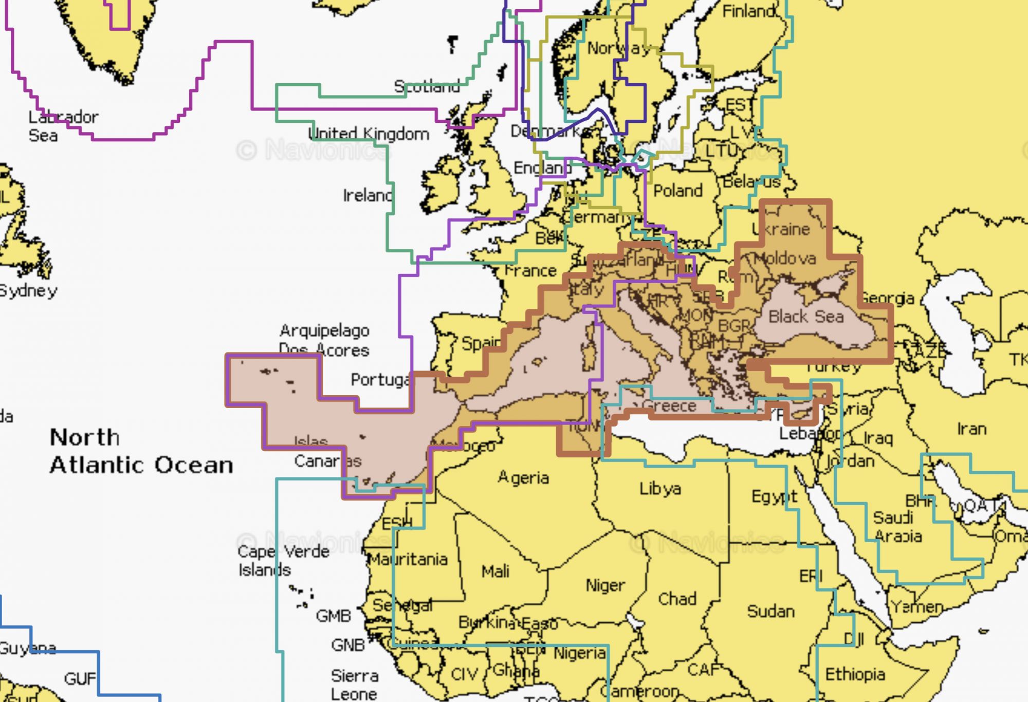
Mediterranean & Black Sea
Chart Code: NAEU643L
Detailed coverage of the Mediterranean and Black Seas. Coverage includes the Azores, Madeira, the Canary Islands, Gibraltar, the Balearic Islands, Corsica, Sardinia, Sicily, Malta, Crete, Cyprus, the Dardanelles, the Bosporos, the Sea of Azov, the Dneiper River to the Kyivs'ke Reservoir, the Danube River to Passau, Germany, Lake Balaton, Lake Garda, Lake Como and Lake Maggiore. Ports include Cadiz and Barcelona, Spain; Monaco; Marseille and Toulon, France; Genoa, Naples, Taranto and Venice, Italy; Istanbul, Turkey; Odessa, Ukraine; Tunis, Tunisia and Algiers, Algeria.
U.K., Ireland & Holland
Chart Code: NAEU628L
Detailed coverage of the UK, Ireland and the North Sea and English Channel coasts. Coverage includes the Shetland Islands, Orkney Islands, Isle of Man, Isle of Wight, the Isles of Scilly, the Channel Islands, the Thames River, the IJsselmeer, the Waddenzee and the Kiel Canal. Ports include London, Liverpool, Southampton, Edinburgh and Belfast, UK; Dublin and Cork, Ireland; Brest, Le Havre, Calais and Dunkirk, France; Antwerp, Belgium; Amsterdam and Rotterdam, The Netherlands; Bremerhaven, Hamburg and Kiel, Germany.
Scandinavia, South & Germany, North
Chart Code: NAEU645L
Detailed coverage of the Skagerrak and Kattegat and the approaches to them. Coverage includes the Scandinavian coast from Kristiansund, Norway to Gavle, Sweden; the Aland Islands; Turku, Finland; Gotland and Bornholm Islands; the Szczecin Lagoon; the Kiel Canal and all of Denmark. Ports include Oslo, Norway; Malmo and Stockholm, Sweden; Copenhagen and Aarhus, Denmark and Hamburg, Germany. Lakes include but are not limited to Lakes Vänern, Vättern, Mjörn, Sommen and Uddjuar in Sweden and Lakes Mjøsa, Bandak, Flåvatn, Norsjø and the Telemark Canal in Norway.
Europe, Central & West
Chart Code: NAEU646L
Detailed coverage of central and western Europe. Coverage includes the European coast from the Szczecin Lagoon to Monaco; the Azores; Madeira; the Canary Islands; the Balearics; Corsica and Sardinia; Gibraltar, the English Channel; the Channel Islands; the IJsselmeer; the rivers of France, Germany and the Low Countries; Lakes Maggiore, Como, Garda, Geneva, Constance and Balaton.
NOTE: Navionics+ and Platinum+ cards are not compatible with Garmin chartplotters.