SPECIFY IN THE ORDER NOTES THE AREA OF INTEREST
Navionics+ Regular SD/MSD Cartography
Navionics+ Regular cartography provides integrated offshore and inland marine mapping content with rivers, bays and more than 42,000 lakes around the world. This all-in-one solution offers clear, reliable cartography for the widest range of chartplotter brands.
THE NAVIONICS SUBSCRIPTION
A one-year subscription to Daily Updates and advanced features is included when you purchase any Navionics+ mapping solution. After a year, you can renew at a discounted price.
CHARTS AND UPDATES
Nautical Chart – Comprehensive charts are derived from multiple official, government and private sources, displayed in a familiar look and feel.
SonarChart HD Bathymetry – Innovative 1' (0.5 m) bathymetry charts are created by using Navionics proprietary systems that augment existing content with sonar data contributed by the boating community.
Community Edits – Get useful local knowledge from edits made by users of the Navionics Boating app on your compatible smart device.
Daily Updates – Up to 5,000 daily updates to our charts give you the most accurate, most current data available.
ADVANCED FEATURES
Dock-to-dock Route Guidance – Start your trip with a suggested dock-to-dock route.
Advanced Map Options – Customize your view to focus on the details that matter most.
Plotter Sync – Transfer routes and markers, update chart layers and more — between your compatible chartplotter and the Navionics Boating app.
SonarChart Live Mapping Feature – Watch new HD depth maps develop in real time as your boat moves through the water.
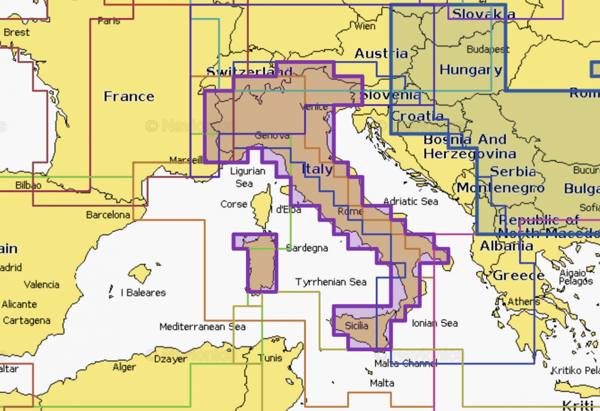
COVERAGE AREAS
Worldwide map coverage is available, with integrated content making it easier to select the navigation features and map regions you want. Choose from large coverage areas (Large) to more localized chart cuts (Regular).
COMPATIBILITY
Check compatibility of Navionics+ content and features with your GPS chartplotter.
Italy, Lakes & Rivers
Chart Code: NAEU073R
Detailed coverage of the lakes and rivers of Italy. Coverage includes the Po River and Lago Maggiore, Lago d'Iseo, Lago di Como and Lago di Garda.
Mediterranean Sea, Cen. & West
Chart Code: NAEU012R
Coastal coverage of the Mediterranean coast from L'Esartit, Spain to Crotone, Italy including Corsica, Sardinia, Sicily and Malta. Also includes coverage of Lac de Geneve, Lago Maggiore, Lago di Lugano, Lago d'Iseo, Lago di Como and Lago di Garda in northern Italy.
Italy, Adriatic Sea
Chart Code: NAEU014R
Coastal coverage of the Po River and the Adriatic coast of Italy, Slovenia, Croatia, Albania, the western coast of Greece and southern Italy. Coverage includes eastern Sicily, the Straits of Messina, the Dalmatian Coast, the Gulf of Taranto, Lago Maggiore, Lago d'Iseo, Lago di Como and Lago di Garda.
Alpine, Lakes & Rivers
Chart Code: NAEU066R
Covers the lakes and rivers of the Alpine region of Europe. Coastal coverage includes Lakes Constance (Upper, Lower and Seerhein), Zurich, Lucerne, Geneva, Thun, Brienz, Annecy, Bourget, d'Aiguebelette, Lake of Sainte-Croix, Neuchatel, Maggiore, Orta, Como, Iseo, Lugano, Garda, Biel and Neusiedl/Ferto. Rivers include the Rhine from its headwaters to Germersheim, the Danube from its headwaters to Bratislava, the Necklar from its headwaters to Offenau and the Main-Danube Canal from Hilpoltein to the Danube. Other rivers include the Isar, the Inn, the Salzach and the Lech in their entireties.
NOTE: Navionics+ cards are not compatible with Garmin chartplotters.