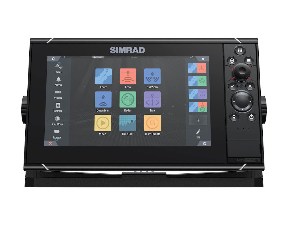
Simrad NSS9 EVO3S COMBO with World Basemap 000-15405-001
A high-definition 9-inch display, that’s great for centre consoles and other powerboats. Featuring the new iMX 8 high-performance processor, with superfast response times, this compact package delivers extensive functionality. Enjoy stunning clarity and ultra-wide viewing angles, combined with an all-weather touchscreen and keypad for total control in all conditions. Includes world basemap.
• MX 8 Integrated six-core processor for superior performance
• 9-inch SolarMAX ™ IPS display with ultra-wide viewing angles; viewable through Polarized sunglasses
• Switch seamlessly between touchscreen and keypad control
• Built in high-performance echosounder with 1kW CHIRP
• Built-in GPS receiver and wireless connectivity
• Control Simrad sonar, radar, autopilot, and other accessories
• Industry-standard connectivity to engines, sound system, and more
• TripIntel™ trip planning and support for automatic routing
• Choose low-profile flush mounting or convenient bracket mounting
• Download the Simrad App and connect with smartphones, tablets, and internet hotspots
• Includes world basemap
Specially designed for sailing
The new Zeus 3S chartplotters offer ultra-fast response times so you have all the information you need, when you need it. Easy to use, Zeus3S features B&G unique navigation features built in, which simplify navigation, calculate routes, add waypoints, and display navigation and racing data at the touch of a button or screen.
Super fast processor for immediate response
Improve your knowledge of your surroundings like never before thanks to the Zeus 3S high-performance processor. The processor power of this chartplotter allows you to simultaneously manage charts, radar, ForwardScan and autopilot controls without compromising performance, and offers all the tools you need to navigate safely, with the certainty of being able to monitor your surroundings.
Functionality for sailing
Navigate safely with B&G's award-winning navigation features for cruising and racing, including;
SailSteer, RacePanel, StartLine, Laylines, SailingTime, Advanced Windplot and Weather Routing with PredictWind integration.
Unbeatable clarity and control
A multi-touch screen and dedicated keyboard combined with our ultra-bright IPS HD SolarMax screen, which supports multiple gestures and wide viewing angles in direct sunlight, offers maximum control and visibility from any angle, light or weather .
Easy network expansion
Simply add power to use the Zeus 3S as a versatile standalone chartplotter with premium navigation features. However, for the best experience, it is easy to network the chartplotter with H5000 IP, AutoPilot, ForwardScan, FLIR IP cameras, NMEA2000 and 0183, as well as the latest HALO and broadband radars, for optimal target detection, low power consumption of energy, immediate ignition and weather mode. Built-in WiFi allows you to connect and play or control the Zeus 3S screen from a smartphone or tablet.
Technical specifications:
Approvals
Compliance: CE, C-Tick, HDMI, EN 60950-1:2006, EN 60945:2002 EN 300 440-2, V1.4.2.
Autopilot
Manouevres/Turn Patterns: U-turn, Spiral-turn, C-turn, Zig-zag, Square-turn, Lazy S-turn, Depth contour tracking;
Steering Modes: Auto, Nav., No Drift, Follow up, Non-follow up, Turn patterns, Standby, *Wind, *Wind NAV. (*Boat type set to Sail).
Connectivity
NMEA 0183 Sentences supported: Input: GGA, GLL, GSA, GSV, VTG, ZDA, RMC, DBT, DPT, MTW, VLW, VHW, HDG, HDT, HDM, MWV, MWD, DSC, DSE, VDM. (Note AIS sentences are not bridged to or from NMEA 2000)Output: GGA, GLL, GSA, GSV, VTG, ZDA, RMC, DBT, DPT, MTW, VLW, VHW, HDG, MWV, MWD, TLL, TTM;
Bluetooth: Internal;
Ethernet: 1 x 5 pin yellow connector x 10/100 Mbit.
N2K PGNs: Receive only59392 ISO Acknowledgement59904 ISO Request60160 ISO Transport Protocol, Data Transfer60416 ISO Transport Protocol, Connection M.65240 ISO Commanded Address60928 ISO Address Claim126208 ISO Command Group Function126992 System Time126996 Product Info126998 Configuration Information127233 Man Overboard Notification (MOB)127237 Heading/Track Control127245 Rudder127250 Vessel Heading127251 Rate of Turn127252 Heave127257 Attitude127258 Magnetic Variation127488 Engine Parameters, Rapid Update127489 Engine Parameters, Dynamic127493 Transmission Parameters, Dynamic127500 Load Controller Connection State / Control127501 Binary Status Report127503 AC input status127504 AC Output Status127505 Fluid Level127506 DC Detailed Status127507 Charger Status127508 Battery Status127509 Inverter Status128259 Speed, Water referenced128267 Water Depth128275 Distance Log129025 Position, Rapid Update129026 COG & SOG, Rapid Update129029 GNSS Position Data129033 Time & Date129038 AIS Class A Position Report129039 AIS Class B Position Report129040 AIS Class B Extended Position Report129041 AIS aids to Navigation129283 Cross Track Error129284 Navigation Data129539 GNSS DOPs129540 AIS Class B Extended Position Report129545 GNSS RAIM Output129549 DGNSS Corrections129551 GNSS Differential Correction Receiver Signal129793 AIS UTC and Date Report129794 AIS aids to Navigation129798 AIS SAR Aircraft Position Report129801 Cross Track Error129802 AIS Safety Related Broadcast Message129283 Cross Track Error129284 Navigation Data129539 GNSS DOPs129540 GNSS Sats in View129794 AIS Class A Static and Voyage Related Data129801 AIS Addressed Safety Related Message129802 AIS Safety Related Broadcast Message129808 DSC Call Information129809 AIS Class B “CS” Static Data Report, Part A129810 AIS Class B “CS” Static Data Report, Part B130060 Label130074 Route and WP Service - WP List - WP Name & Position130306 Wind Data130310 Environmental Parameters130311 Environmental Parameters130312 Temperature130313 Humidity130314 Actual Pressure130316 Temperature, Extended Range130569 Entertainment - Current File and Status130570 Entertainment - Library Data File130571 Entertainment - Library Data Group130572 Entertainment - Library Data Search130573 Entertainment - Supported Source Data130574 Entertainment - Supported Zone Data130576 Small Craft Status130577 Direction Data130578 Vessel Speed Components130579 Entertainment - System Configuration Status130580 Entertainment - System Configuration Status130581 Entertainment - Zone Configuration Status130582 Entertainment - Zone Volume Status130583 Entertainment - Available Audio EQ Presets130584 Entertainment - Bluetooth Devices130585 Entertainment - Bluetooth Source StatusTransmit60160 ISO Transport Protocol, Data Transfer60416 ISO Transport Protocol, Connection M.126208 ISO Command Group Function126992 System Time126993 Heartbeat126996 Product Info127237 Heading/Track Control127250 Vessel Heading127258 Magnetic Variation127502 Switch Bank Control128259 Speed, Water referenced128267 Water Depth128275 Distance Log129025 Position, Rapid Update129026 COG & SOG, Rapid Update129029 GNSS Position Data129283 Cross Track Error129285 Navigation - Route/WP Information129284 Navigation Data129285 Route/Waypoint Data129539 GNSS DOPs129540 GNSS Sats in View130074 Route and WP Service - WP List - WP Name & Position130306 Wind Data130310 Environmental Parameters130311 Environmental Parameters130312 Temperature130577 Direction Data130578 Vessel Speed Components.
NMEA 0183: 1 x Transmit, 1 x Receive NMEA 0183, Baud Rates 4800, 9600, 19200, 38400. TX and RX use same baud rate. Optional data cable required (P/N 000-00129-001);
NMEA 2000: 1 x NMEA 2000 Micro-C port, 1 LEN;
PC Connectivity: No;
Video: 2 x composite (RCA connectors)video inputs. Optional video/ data cable required (P/N 000-00129-001);
WiFi: Internal.
Display
Backlight Color: White;
Resolution: 1280 x 720;
Screen Brightness: 1200 nits;
Size and Type: High Visibility SolarMax HD® IPS optically bonded TFT;
Viewing Angles: 80° top/bottom, 80° left/right.
Electrical
Power Consumption, max.: 21 W;
Recommended Fuse Rating: 5A;
Supply Voltage: 10 - 31.2 V DC;
Humidity: IEC 60945 Damp heat 66°C (150°F) at 95% relative (48 hr).
Environment
Operating Temperature Range: -15°C to +55°C (5° F to 131° F);
Shock and Vibration: 100 000 cycles of 20 G;
Storage Temperature Range: -20°C to +60°C (4°F to 140°F);
Waterproof rating: IPX6 and 7.
GPS
Correction: WASS, MSAS, EGNOS, GLONASS Galileo, Beidou, QZSS.SBAS;
GPS Receiver Channels: 34 Channels;
Position Accuracy: Horizontal Accuracy 3 m (9.8 ft);
Time to First Fix: Cold start 50 sec, Satellite Reacquisition 5 sec;
Update rate: 10 Hz;
MFD
AIS: Receive AIS data over NMEA 2000 or *NMEA 0183 (*NMEA 0183 has to be wired to all NSS processors);
Autopilot: Full auto pilot control and commissioning;
Cartography included: World basemap;
Cartography supported; Insight, Navionics (Gold, NAV+ Platinum+), C-MAP (MAX N, MAX N+, Reveal) NV Digital (Raster US Charts);
Digital Switching: C-Zone, Naviop;
External Storage: 2 MicroSD slots, max. 32GB each. Larger if formatted to NTFS;
GPS: Built-in 10 Hz GNSS receiver for GPS and GLONASS, supports combinations with Galileo, Beidou, QZSS.SBAS (WAAS, EGNOS, MSAS, GAGAN);
Internal Storage: 16 GB;
Multimedia: via SonicHub2, FusionLink, *Sirius, **JL Audio. *USA only, **AUST. & NZ only);
Radar (inc. compatibility): Halo Pulse Compression Radars, Broadband Radars, HD Pulse Radar;
Sonar (inc. compatibility): Two 9 pin Xsonic Sonar ports. Sonar port 1: Single channel CHIRP, 50/200 khz, HDI. Sonar port 2: Single channel CHIRP, 50/200 khz, TotalScan, LSS HD, ForwardScan. Compatible with: SonarHub, BSM-3, BSM-2, network echo sounders;
Weather: SiriusXM via WM-3 / WM-4 (USA only), GRIB;
Waypoints, Routes, Tracks: 6000 waypoints, 500 Routes with 100 max route points, 50 tracks with up to 12,000 track points;
Compass Safe Distance - Metric, imperial: 50 cm (1.7 ft).
Physical
Dimensions (WxHxD): 287x166x90 mm (11.30x6.55x3.50")with bracket 311x180x95 (11.30x7.07x3.72);
Mounting Type: Bracket (Supplied) or panel mount;
Weight: 41 kg (3.11 lbs.).
Other
Warranty Period 2 Years;
Interface: Full touch screen (multi-touch ) and full keypad control, OP50 remote controllers;
Languages: Standard Language Pack: English(US), English(UK), Danish, German, Spanish, Finnish, French, Greek, Icelandic, Italian, Dutch, Norwegian, Portuguese, SwedishOther languages supported by Unlock:Japanese, Korean, Thai, Chinese, Bulgarian, Hebrew, Croatian, Hungarian, Lithuanian, Latvian, Polish, Slovak, Turkish, Russian, Ukrainian, Arabic, Farsi.
Comes with
- 000-13741-001 NSS9 EVO3 SUN COVER
- 000-13758-001 NSS9 EVO3 & ZEUS3-9 GIMBAL BRCKT
- 000-13754-001 NSS9 evo3 & Zeus³ 9 Dash Mount Kit.
- 000-13750-001 NSS9 evo3 & Zeus³ 9 Edge Bezels
- 000-00128-001 POWER CABLE SIMRAD 4PIN